 |


Next: Aurora and artificial airglow
Up: Introduction
Previous: Introduction
Contents
ALIS
The ALIS (Auroral Large Imaging
System) project ( Steen and Brändström, 1993) is a ground-based optical system for
measuring the aurora, high-altitude clouds, and other atmospheric optical
signatures at high latitude. It is composed of a grid of stations with
approximately 50 km separation and consists currently (summer 2000) of six
stations in regular unmanned operation ( Brändström and Steen, 1994). In joint
campaigns ( Aso et al., 1998b) the system has been set up and operated
with six manned and unmanned stations. Each station is equipped with
a sensitive high-resolution CCD camera operated and controlled
remotely. At the time of writing, the ALIS system consists of four CCD
cameras with telecentric optics and  fields-of-view (side
to side) and two CCD cameras with approximately fields-of-view (side
to side) and two CCD cameras with approximately  fields-of-view. The cameras are equiped with narrow (
 Å) interference filters for imaging of the auroral green line Å) interference filters for imaging of the auroral green line
 Å Å , the auroral red line , the auroral red line
 Å, a Å, a  1NG emission 1NG emission
 Å,
and a near IR emission Å,
and a near IR emission
 Å. The
approximate sensitivity is 24 Rayleigh per count. The instrument
noise is between 5 and 10 counts, which should be compared with the
photon count statistics that give random fluctuations that are larger;
the ALIS cameras actually measure the random fluctuations of the photon
emission. With the current cameras and software it is possible to take
images with exposure times down to 50 ms, with a frame rate of one
image every 10 s at full resolution, and up to one image every 3-5
s with reduced resolution (Brändström, private communication). One
of the major scientific objectives of ALIS is to retrieve
three-dimensional (3-D) distributions of auroral emissions with the aid of
tomographic inversion techniques. This has influenced the design of
the entire experimental configuration, i.e., geographical location
of the stations, the optics, and other relevant experimental
parameters. The geometry of the stations is optimised for reconstruction of the spatial distribution of aurora in the
Kiruna region.
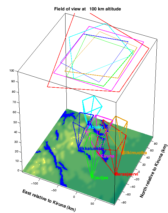
In order to obtain a three-dimensional reconstruction of the aurora
which is accurate in as large a volume as possible,
a number of orientations of the cameras are designed to make as large
a volume as possible fall within the field-of-view of all cameras. In
Figure 1.1 the approximate fields of view at 100 km
altitude are plotted with all cameras in the ``core mode''; that is,
the cameras are directed towards a point above Kiruna. Å. The
approximate sensitivity is 24 Rayleigh per count. The instrument
noise is between 5 and 10 counts, which should be compared with the
photon count statistics that give random fluctuations that are larger;
the ALIS cameras actually measure the random fluctuations of the photon
emission. With the current cameras and software it is possible to take
images with exposure times down to 50 ms, with a frame rate of one
image every 10 s at full resolution, and up to one image every 3-5
s with reduced resolution (Brändström, private communication). One
of the major scientific objectives of ALIS is to retrieve
three-dimensional (3-D) distributions of auroral emissions with the aid of
tomographic inversion techniques. This has influenced the design of
the entire experimental configuration, i.e., geographical location
of the stations, the optics, and other relevant experimental
parameters. The geometry of the stations is optimised for reconstruction of the spatial distribution of aurora in the
Kiruna region.
In order to obtain a three-dimensional reconstruction of the aurora
which is accurate in as large a volume as possible,
a number of orientations of the cameras are designed to make as large
a volume as possible fall within the field-of-view of all cameras. In
Figure 1.1 the approximate fields of view at 100 km
altitude are plotted with all cameras in the ``core mode''; that is,
the cameras are directed towards a point above Kiruna.
Figure 1.1:
field-of-view at 100 km altitude for the cameras oriented
towards a point above the Kiruna station, the ``core mode''.
 |
Next: Aurora and artificial airglow
Up: Introduction
Previous: Introduction
Contents
copyright Björn Gustavsson 2000-10-24
|